

Original file (974 × 632 pixels, file size: 233 KB, MIME type: image/png)
Summary
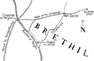
Map of western Brethil published in The Children of Húrin. The map by Christopher Tolkien is a redrawing of the one he sketched for Unfinished Tales, showing the path Túrin and his companions took to attack Glaurung. Starting in Nen Girith, they travelled towards the Crossings of Taeglin before turning down a narrow track and following the river through the woods towards Cabed-en-Aras.[1]
References
- ↑ J.R.R. Tolkien, Christopher Tolkien (ed.), The Children of Húrin, "Appendix 2: The Composition of the Text"
Licensing
This work is copyrighted and owned by the Tolkien Estate. It is believed that the limited use of this file,
- on the not-for-profit educational Tolkien Gateway website,
qualifies as fair use under copyright law in the United States of America.
File history
Click on a date/time to view the file as it appeared at that time.
| Date/Time | Thumbnail | Dimensions | User | Comment | |
|---|---|---|---|---|---|
| current | 02:25, 12 July 2024 | | 974 × 632 (233 KB) | Oromë (talk | contribs) |
You cannot overwrite this file.
File usage
The following page uses this file: