Latest comment: 24 April3 comments2 people in discussion
How is it the southernmost peak of the Misty Mountains, where the Entwash originates? The Entwash originates near the Wellinghall, does it not? The Misty Mountains extend further south than this. Smeagol (talk) 13:03, 17 April 2026 (UTC)Reply[reply]
Because J.R.R. Tolkien heavily implied that it is with the word "last" in the context of the paragraph, with his translation of the Sindarin name Methedras and with the map. In edition he wrote "Methedras, the last peak of the Misty Mountains" in the narrative of LOTR. J.R.R. Tolkien did not write that the spring of the Entwash was at Wellinghall. He wrote in his entry for Methedras in his Unfinished Index for LOTR "the southernmost of the last major peaks of the Misty Mountains" and in his entry for the Misty Mountains in this Unfinished Index "the great range (called in E[lvish] Hithaeglir "line of misty peaks"), running more or less from N[orth] to S[outh] from Mt. Gundabad about 200 miles n[orth] of Rivendell, to Methedras about 400 miles s[outh] of Rivendell".
Did you read the sources that are indicated in the references on the Methedras page?
Did you consider that there is a difference between the peak of a mountain and the mountain itself and between a mountain and hills, especially foothills of mountains? A mountain can extend further south than its peak and foothills of a mountain or a mountain chain can extend further south than the mountain or mountains themselves.
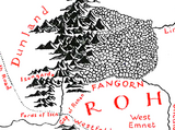
J.R.R. Tolkien explicitly stated in the chapter The Riders of Rohan: "North-westward stalked the dark forest of Fangorn; still ten leagues away stood its shadowy eaves, and its further slopes faded into the distant blue. Beyond there glimmered far away, as if floating on a grey cloud, the white head of tall Methedras, the last peak of the Misty Mountains." In the context of the General Map of Middle-earth with pictorals for mountains and hills that was drawn by Christopher Tollien based on The Third Map of The Lord of the Rings with contour lines for elevations that was drawn by J.R.R. Tolkien "last peak of the Misty Mountains" means southermost peak of the Misty Mountains.
J.R.R. Tolkien wrote in the chapter Treebeard: "At last the hobbits saw, rising dimly before them, a steep dark land: they had come to the feet of the mountains, and to the green roots of tall Methedras. Down the hillside the young Entwash, leaping from its springs high above, ran noisily from step to step to meet them.", "A little stream escaped from the springs above, and leaving the main water, fell tinkling down the sheer face of the wall, pouring in silver drops, like a fine curtain in front of the arched bay. The water was gathered again into a stone basin in the floor between the trees, and thence it spilled and flowed away beside the open path, out torejoin the Entwash in its journey through the forest. and ". ‘I wonder where Isengard is?’ said Pippin.‘I don’t know quite where we are,’ said Merry; ‘but that peak is probably Methedras, and as far as I can remember the ring of Isengard lies in a fork or deep cleft at the end of the mountains." --Akhôrahil (talk) 13:00, 19 April 2026 (UTC)Reply[reply]
Hi. So, am I to understand that the published CT map is inaccurate? What is the course of the Onodló through Frangorn forest? What does "the southernmost of the last major peaks of the Misty Mountains" mean? Are those peaks that are further south (and even West of the Angren) not considered major? Smeagol (talk) 15:45, 24 April 2026 (UTC)Reply[reply]