
 | |
| Region | |
| The Shire | |
|---|---|
| General Information | |
| Other names | Sûza (W) Drann (S) |
| Location | Eriador |
| Type | Region |
| Regions | Eastfarthing, Southfarthing, Northfarthing, Westfarthing; Buckland, Westmarch; Bridgefields, Green Hill Country, Marish, Tookland, Woody End |
| Major Settlements | Bywater, Hobbiton, Michel Delving, Tuckborough |
| People and History | |
| Inhabitants | Hobbits |
| Created | T.A. 1601[1][2] S.R. 1452 - Westmarch added to the Shire[3] |
| Events | Battle of Greenfields Battle of Bywater |
| Gallery | Images of the Shire |
Geography
The Shire is described as a small but beautiful and fruitful land, beloved by its inhabitants. The Hobbits had an extensive agricultural system in the Shire, but did not proceed with industrialisation. Various supplies could be found in the Shire, including cereals, fruit, wood and pipe-weed (a favourite treat of Hobbits).
The Shire was quite densely populated in parts with many villages and a few towns, but it still was open enough to allow for wide forested areas and marshes. There were green, rolling hills and freshly tilled earth, along with gardens and flower boxes on window sills.
Thanks to the protective presence of the Rangers of the North in the lands of the former Arnor, the Shire for centuries ignored the wide world outside, despite being traversed by the East Road.
From the west to the east, the Shire originally measured 40 leagues (120 miles) from the Far Downs to the Brandywine Bridge. From the north to the south, it measured 50 leagues (150 miles) from the northern moors to the marshes in the south.[1] The total area of the Shire must have extended roughly about 20,000 square miles.[note 1]
In S.R. 1452, King Elessar gave the Westmarch to the Shire-hobbits as a gift. This extended the western boundaries of the Shire to the Tower Hills.[3] Buckland, to the east of the Brandywine, remained an independent region occupied by Hobbits.

The boundaries of the Shire were as follows:[1]
| Boundaries of the Shire | ||
|---|---|---|
| North Moors | Possibly Dwaling | |
| Tower Hills |  | Brandywine River |
| Marshes in the south | Possibly Sarn Ford | |
History
But it is not your own Shire. Others dwelt here before hobbits were; and others will dwell here again when hobbits are no more. The wide world is all about you: you can fence yourselves in, but you cannot for ever fence it out.
The Shire was a fertile and well-tilled part of Arnor, with many royal farms, cornlands, vineyards, and woods. It had long been deserted during the waning days of the Kingdom when it was known as the splinter-realm of Arthedain;[1] it had been the hunting grounds of the King of Arnor.[4] The Hobbits from Bree got official permission from King Argeleb II at Norbury (Fornost) to settle the lands. This was finally done in T.A. 1601 (Year 1 in Shire Reckoning) by Hobbits from Bree, led by the brothers Marcho and Blanco.[1] They were joined by other hobbits who lived in Dunland and parts of depopulated Cardolan and Rhudaur.

By 30 years later, almost all of the Hobbits of Middle-earth could be found in the Shire. The Shire-hobbits considered themselves as subjects of the King, at least nominally, considering the isolation of their country. Nevertheless the Hobbits sent some support troops to the great battles Arnor fought against Angmar. After the fall of Arnor, the Shire remained a minor but independent political unit and the title of Thain was established to fill the absence of a Kingship.[1]
Its small size, relative lack of importance, and brave and resilient Hobbit population made it too modest an objective for conquest. More important was that the Shire was guarded and protected by the Dúnedain Rangers of the North (and Gandalf), who watched the borders and kept out intruders. The only strangers to enter the Shire were the Dwarves travelling on the East Road that ran through the Shire to and from their mines in the Blue Mountains, and the occasional Elves on their way to the Emyn Beraid or the Grey Havens.
In T.A. 2340, the Oldbucks of the Marish crossed the Brandywine because of overpopulation and founded Buckland.
However, the Shire faced its adversities since it was inside the range of the Great Plague of T.A. 1636, and Goblins from Mount Gram invaded the Shire until they were driven out after the Battle of Greenfields (T.A. 2747). The Shire also suffered because of the Long Winter (T.A. 2758) soon followed by the Days of Dearth (T.A. 2760) and the Fell Winter (T.A. 2911) when White Wolves entered the Shire.[2]
Saruman followed Gandalf's interest for the Hobbits and put spies in Bree and Southfarthing. In the years leading up to the War of the Ring, his spies saw that the Shire was closely guarded by the Rangers. When Gandalf suspected that Bilbo Baggins possessed the One Ring the guard was doubled[2] (perhaps at his request to Chieftain Aragorn).
War of the Ring
During the War of the Ring, the Shire was first visited by the Nine Ringwraiths when the Rangers were off to the War. This left the Shire defenseless, leaving it open to be captured by Sharkey (Alias of Saruman) and some Ruffians, through the use of Lotho Sackville-Baggins. It was liberated after Frodo, Sam, Merry and Pippin returned from Gondor. Their victory at the Battle of Bywater and the death of Saruman put a final end to the War.
Yet the physical damage which Saruman caused by forced industrialisation was undone by the Hobbits' efforts and the soil from Lothlórien (given to Sam by Galadriel) and T.A. 3021 was considered to be the most productive and prosperous year in their history.
Fourth Age
With Aragorn's return as the King of Arnor and Gondor, the Shire joined the Reunited Kingdom[5] and in Fo.A. 6 became a Free Land, protected enclave inside the Kingdom; a royal order forbade the entrance of any one other than Hobbits into the Shire. In Fo.A. 31, King Aragorn extended the land westwards to Emyn Beraid; this land was named Westmarch and many hobbits relocated there.[6]
Administration

At its founding, the Shire was a part of Arthedain and the Hobbits considered themselves to be subjects of the King. It was only after the fall of Arthedain that the Shire became an independent state. Once independent, the Hobbits of the Shire selected a Thain to lead them. The office of Thain was hereditary, initially belonging to the Oldbuck family. When the Oldbucks left the Shire for Buckland, the office passed to the Took family of Tuckborough. While nominally the Thain ruled over the four Farthings, in practice authority was so decentralised that the title was seen as more of a formality and ceremonial.
The Shire was originally divided into four Farthings (Northfarthing, Southfarthing, Eastfarthing, and Westfarthing). Within the Farthings there were smaller, unofficial divisions, such as towns or regions associated with particular families. The Tooks, for instance, mostly lived in or near Tuckborough. In many cases, Hobbit family names were derived from their places of origin. For example, Samwise Gamgee's surname was derived from the town of Gamwich whence the family originated.
The only elected official of the Shire was the Mayor of Michel Delving in the White Downs (by extension seen as the mayor of the Shire). The Mayor's chief duties were serving as postmaster of the Shire's Messenger Service, charging the Watch, and presiding at fairs.
The sole law enforcement officials in the Shire were the Shirriffs. Their primary responsibility was the protection of the Shire from trespassers. There were three in each Farthing and were distinguished from "civilians" by a feather worn in their caps. The Bounders were the land's border-guard, charged with turning back unwanted people or beasts; their number varied according to need.
After Westmarch was added to the Shire, the Thain established the title of Warden of Westmarch. This was a hereditary office with unclear responsibilities. It was first given to the Fairbairns, descendants of Samwise Gamgee.
Buckland, which was not part of the Shire proper, was controlled by the Master of Buckland at Bucklebury. The office of Master was established by the Oldbucks when they left the Shire. Their descendants continued to hold the office when they became the Brandybucks.
Etymology
A "shire" (Old English scír) is an organised region with a county town, which in the case of the Hobbits' Shire was Michel Delving.[7] Tolkien notes that the usual Germanic word for "district", represented in Dutch by gouw and in German by Gau, was replaced in English by scír at an early date. Ge, the English cognate of these words, survives only in a handful of place-names, such as Surrey (from Old English Suðer-ge, "southern district").[7]
Other names
The original Westron name for "Shire" was Sûza,[8] while the definite form ("The Shire") was Sûza-t.[9]
The Sindarin name is only attested in the lenited form Drann and the adjectival Drannail,[10][11] so it would be Trann.[12]
Inspiration
I could draw you a map of every inch of [Sarehole] [...] I loved it with an intensity of love that was a kind of nostalgia reversed [...] It was a kind of lost paradise and it was wonderful.
On Tolkien's maps, the Shire is located at about the same position as England is on modern European maps and has been cited as an example of Deep England ideology (though, of course, England is on an island while the Shire is a landlocked country). Throughout the narrative, Tolkien also implies numerous points of similarity between the two, such as weather, agriculture and dialect. One can also see England as Tolkien's source of inspiration for the Shire in its very name. Tolkien had spent his youth in Sarehole, Worcestershire.
According to Paula Marmor, the hobbit brothers Marcho and Blanco bear names related to horses, parallel to Hengest and Horsa, the legendary leaders who brought the Saxons to Britain. Hengest was the founder of Kent whose geography is similar to the Shire (North Downs above, hills to the west, water to the east and marshes to the southeast).[14]
The industrialisation of the Shire was based on Tolkien's witnessing of the extension of the Industrial Revolution to rural Warwickshire during his youth, and especially the deleterious consequences thereof. The rebellion of the hobbits and the restoration of the pre-industrial Shire may be interpreted as a prescription of voluntary simplicity as a remedy to the problems of modern society.
Portrayal in adaptations
Pictures of the Shire in adaptations
-

The Shire in The Lord of the Rings: The Fellowship of the Ring
-

Map of the Shire from The Lord of the Rings Online
-
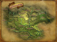
Map of the "Yondershire" from The Lord of the Rings Online


Films
1977: The Lord of the Rings (1978 film):
- The Shire is featured in the opening and last scenes of the film. Only Bag End is featured extensively.
2001-03: The Lord of the Rings (film series):
- Shire scenes were shot on location in Matamata, New Zealand. Following the shooting, the area was returned to its natural state, but even without Hobbit holes it became a prime tourist attraction.
2012-14: The Hobbit (film series):
- Shire scenes were shot at the same place where shooting of The Lord of the Rings (film series) took place. Unlike the previous time, Hobbiton was constructed out of permanent materials, with intention of lasting for decades.
Games
2002: The Lord of the Rings: The Fellowship of the Ring (video game):
- The first three levels of the game take place in the Shire, from Frodo leaving Bag End up until the entrance into the Old Forest.
2003: The Hobbit (2003 video game):
- The Shire is the first level of the game. Unlike the original story, Bilbo has to perform various side-quests before he ever reached Green Dragon.
2006: The Lord of the Rings: The Battle for Middle-earth II:
- The Shire is a battleground appearing in Evil campaign and skirmish mode.
2007: The Lord of the Rings Online:
- The Shire is one of the starting regions of the game, where Hobbit-characters start, represented almost in its entirely - of the original map by Christopher Tolkien only some parts of Westfarthing and Southfarthing are not represented. Also, part of the Northfarthing is placed within the borders of Evendim region for gameplay purposes. The Shire is inhabited by hundreds of non-playable characters, involved in hundreds of quests.
- In 2022 an extension to the region called "the Yondershire" was added. This area includes the Shire's less-tamed north-western reaches and the surrounding territory, reaching to the River Lune in the west and the Hills of Evendim in the north. It encompasses the rest of the Northfarthing, and most of the Westfarthing that wasn't yet in the game. It is made for players of a higher level.[15][16]
2009: The Lord of the Rings: Conquest:
- The Shire is one of game's battlegrounds, razed by Sauron's forces in the Evil campaign.
2010: The Lord of the Rings: Aragorn's Quest:
- The Shire is featured in the beginning of the game.
See also
Notes
- ↑ Robert Foster estimates the total area of the Shire to be "about 18,000 square miles"; Karen Wynn Fonstad has calculated a larger figure, about 21,400 square miles. See: Robert Foster, The Complete Guide to Middle-earth, entry "Shire" and Karen Wynn Fonstad (1991), The Atlas of Middle-earth, revised edn (London: HarperCollins, 1991), p. 69
References
- ↑ 1.0 1.1 1.2 1.3 1.4 1.5 J.R.R. Tolkien, The Lord of the Rings, "Prologue", "Concerning Hobbits"
- ↑ 2.0 2.1 2.2 J.R.R. Tolkien, The Lord of the Rings, Appendix B, "The Third Age"
- ↑ 3.0 3.1 J.R.R. Tolkien, The Lord of the Rings, Appendix B, "Later Events Concerning the Members of the Fellowship of the Ring"
- ↑ J.R.R. Tolkien, Christopher Tolkien (ed.), The Peoples of Middle-earth, "I. The Prologue", p.9
- ↑ J.R.R. Tolkien, The Lord of the Rings, "Prologue", "Note on the Shire Records"
- ↑ J.R.R. Tolkien, The Lord of the Rings, Appendix B, "Later Events Concerning the Members of the Fellowship of the Ring"
- ↑ 7.0 7.1 J.R.R. Tolkien, "Nomenclature of The Lord of the Rings" in Wayne G. Hammond and Christina Scull (eds), The Lord of the Rings: A Reader's Companion, p. 775
- ↑ J.R.R. Tolkien, The Lord of the Rings, Appendix F, "On Translation"
- ↑ J.R.R. Tolkien, Christopher Tolkien (ed.), The Peoples of Middle-earth, "II. The Appendix on Languages", p. 45
- ↑ Vinyar Tengwar 31, "The King's Letter: An Historical and Comparative Analysis" by Carl F. Hostetter, pp. 21-22
- ↑ J.R.R. Tolkien, Christopher Tolkien (ed.), Sauron Defeated, "Part One: The End of the Third Age: XI. The Epilogue: The second version", p. 129
- ↑ . "S. #Trann loc.". Eldamo - An Elvish Lexicon. Retrieved 22 January 2020
- ↑ Oxford Mail, 3 August 1966, p. 4
- ↑ Jim Allan (1978), An Introduction to Elvish, "An etymological excursion among the Shire-Folk" by Paula Marmor
- ↑ "Update 33 Release Notes". The Lord of the Rings Online
- ↑ . "A Casual Stroll Through Yondershire with Scenario". Twitch
- ↑ Tales of the Shire: A The Lord of the Rings Game - Trailer | Nintendo Direct 2024
| Route of Thorin and Company |
|---|
| Bag End · Green Dragon · The Shire · Lone-lands · Last Bridge · Trollshaws · Trolls' lair · Rivendell · High Pass · Front Porch · Goblin-town · Goblin-gate · Eagle's Eyrie · Carrock · Beorn's Hall · Wilderland · Forest Gate · Elf-path · Mirkwood · Elvenking's Halls · Forest River · Lake-town · Long Lake · River Running · Desolation of the Dragon · Ravenhill · Back Door · Lonely Mountain · Great Hall of Thráin |
| Thains of the Shire |
|---|
| Bucca of the Marish (from S.R. 379) · 10 unknown Oldbucks · Gorhendad Oldbuck (until S.R. 740) · Isumbras I (from S.R. 740) · 8 unknown Tooks (includes: Isengrim I · Ferumbras I · Paladin I · Isumbras II) · Isengrim II (S.R. 1083 - 1122) · Isumbras III (1122 - 1159) · Ferumbras II (1159 - 1201) · Fortinbras I (1201 - 1248) · Gerontius (1248 - 1320) · Isengrim III (1320 - 1330) · Isumbras IV (1330 - 1339) · Fortinbras II (1339 - 1380) · Ferumbras III (1380 - 1415) · Paladin II (1415 - 1434) · Peregrin I (1434 - 1484) · Faramir I (from 1484) |